
 The Kuskulana River sits beneath a deep gulch on the McCarthy Road.
Part 2 of our weekend excursion took us to McCarthy and Kennicott located in southeast Alaska in Wrangell-Saint Elias National Park. This was a brand new place and even a new road for me. We parked the car in McCarthy, packed up the bike and bike trailer (thanks to Helena for the borrow!) and we were off to the town of Kennicott, 5 miles up the road. 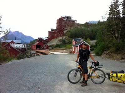 I was pretty wiped out from the Klutina Lake Rd. excursion so getting to the Root Glacier trail was tough. But, we made it up to one of the camping areas with a bear-safe box for our food.. convenient!
 I was pretty wiped out from the Klutina Lake Rd. excursion so getting to the Root Glacier trail was tough. But, we made it up to one of the camping areas with a bear-safe box for our food.. convenient!
 Our campsite was pretty sweet, just off of the trail overlooking the glacier. We had a bit of rain overnight but for morning it was just overcast.
 The camping area even had an outhouse - luxury!
 The Root Glacier trail was easy going for the first mile and a half to Jumbo camping area. From the camping area, the trail goes to an advanced singletrack and is SUPER fun!
 Though, wet roots and steep embankments are not always the best combination. Above is the status of my bike after not clearing the tiny little wet root, and I went ROLLING down the cliff on the left side. Luckily for me, I stopped down the hill a ways, while laughing hysterically...avoiding any rocks and just getting a little scratched up. I've never landed that far away from my bike before!! Tuck 'n roll skills were particularly useful for this moment.
 This was Brian's first singletrack riding ever, and he loved it.. which is good for me!
 View of the Root Glacier. We never actually did go up to the glacier, which seems ridiculous, but we were so focused on biking the trail alongside the glacier.
 We ditched the bikes part way through the trail, because the trail got unridable.
 This section was scary to walk across let alone bike across.
 The Erie Mine is located at the top of these cable lines on the side of the trail. After these cable lines, the trail ends overlooking the glacier and icefall.
 Here's a map of our route:
 Awesome trip - the entire weekend it only rained on us when we were in the car or in the tent. A short little exploratory overnight trip to McCarthy and Kennicott. We'll be back!


